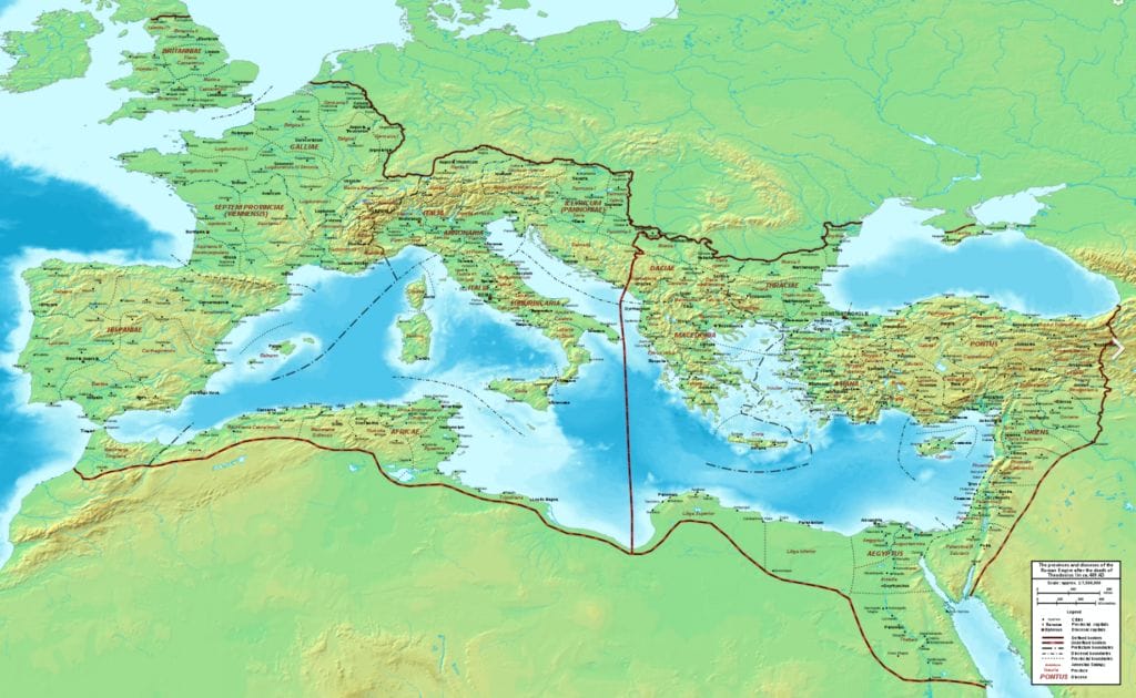
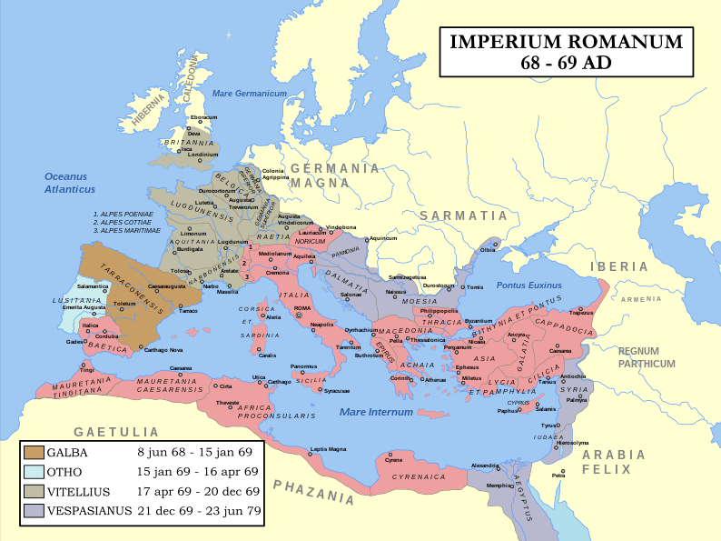
Roman Empire Map
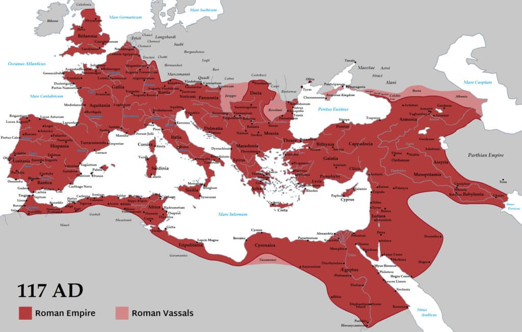
This map of ancient Rome shows the vast territory it covered. At the time of Emperor Trajan’s death in 117 AD, the Roman Empire was the largest it would be in history.
It spanned from England to the west coast of modern-day Spain to South in Egypt and East to the Persian Gulf.
Rome reached its largest territorial extent during the period known as the Roman Empire. The Roman Empire’s peak size occurred in the year 117 CE (Common Era) under the reign of Emperor Trajan. At that time, the empire encompassed vast regions of Europe, North Africa, and the Middle East, making it one of the largest empires in history.
The territorial expanse of the Roman Empire included most of continental Europe, from Britain in the northwest to the Black Sea in the northeast, and from the Atlantic Ocean in the west to the Euphrates River in the east. It extended southward into the African continent, comprising territories in modern-day Egypt, Libya, and Tunisia. The Roman Empire also controlled parts of the Arabian Peninsula, including present-day Jordan and Israel.
It is important to note that the exact territorial boundaries of the Roman Empire varied over time due to conquests, territorial losses, and shifting political circumstances. However, during the reign of Emperor Trajan in the 2nd century CE, the Roman Empire reached its largest territorial extent, encompassing an area of approximately 5 million square kilometers (1.9 million square miles).
After this peak, the Roman Empire faced challenges, including external invasions, internal conflicts, and gradual territorial decline. Over the subsequent centuries, the empire underwent significant transformations, eventually splitting into the Western Roman Empire and the Eastern Roman Empire (later known as the Byzantine Empire). The Western Roman Empire faced further decline and ultimately fell in 476 CE, while the Eastern Roman Empire endured until the 15th century.
Which countries were part of the Roman Empire?

The Roman Empire expanded across various regions, encompassing a significant number of modern-day countries. While the exact borders and territorial control shifted over time, here are some of the countries or regions that were part of the Roman Empire at different periods:
- Italy (including Rome itself)
- Spain (Hispania)
- France (Gaul)
- United Kingdom (Britannia)
- Portugal (Lusitania)
- Belgium and the Netherlands (Gallia Belgica)
- Germany (Germania)
- Switzerland (Helvetia)
- Austria (Noricum and Pannonia)
- Greece (Achaea and Macedonia)
- Turkey (Asia Minor, also known as Anatolia)
- Egypt (Aegyptus)
- Libya (Africa Province)
- Tunisia (Africa Province)
- Algeria (Africa Province)
- Morocco (Mauretania)
- Israel and Palestine (Judea and Roman Syria)
- Jordan (Arabia Petraea)
- Lebanon (Phoenicia)
- Syria (Roman Syria)
- Iraq (Mesopotamia)
- Iran (Persia, briefly under Emperor Trajan)
- Algeria (Numidia)
- Tunisia (Numidia)
- Serbia (Moesia)
- Bulgaria (Thrace)
- Romania (Dacia)
This list provides a general overview of the countries and regions that were part of the Roman Empire. It’s important to note that the Roman Empire’s territorial extent varied over time due to conquests, administrative changes, and shifting borders.
When did the Roman Empire start and finish?

The Roman Empire had a long and complex history, with its beginnings marked by the establishment of the Roman Republic. The traditional date for the founding of Rome is 753 BCE (Before Common Era), and the Roman Republic emerged around 509 BCE. However, it was not until the rise of Julius Caesar and the subsequent transformation of the Republic into an autocratic regime that the Roman Empire truly began.
The Roman Empire officially started in 27 BCE when Octavian, later known as Augustus, became the first Roman Emperor. Augustus’ reign marked the transition from the Roman Republic to the Roman Empire, establishing a centralized imperial rule that lasted for centuries.
The Western Roman Empire, which refers to the western half of the empire, faced significant decline and challenges over time. Its final collapse is typically dated to 476 CE when Romulus Augustus, the last Western Roman Emperor, was deposed by the Germanic chieftain Odoacer.
Meanwhile, the Eastern Roman Empire, also known as the Byzantine Empire, continued to thrive. Its capital was Constantinople (present-day Istanbul) after the city’s founding by Emperor Constantine in 330 CE. The Byzantine Empire endured until 1453 CE when Constantinople fell to the Ottoman Turks, marking the end of the Roman Empire in the East.
To summarize, the Roman Empire began with the establishment of autocratic rule under Augustus in 27 BCE and lasted in the West until 476 CE, while the Eastern Roman Empire (Byzantine Empire) endured until 1453 CE.
Where is Roman Empire located today?
The Roman Empire, as it existed in ancient times, is not located in its original form today. The empire spanned various regions in Europe, North Africa, and the Middle East. Many of the countries that were part of the Roman Empire have evolved and transformed over the centuries.
Today, the territories once under the Roman Empire are encompassed by multiple modern-day countries. Here are some of the regions and countries that were once part of the Roman Empire and their corresponding locations today:
- Italy: Rome, the heart of the Roman Empire, is located in modern-day Italy.
- France: Gaul, which was part of the Roman Empire, corresponds to present-day France.
- Spain: The Iberian Peninsula, known as Hispania during Roman times, includes modern-day Spain and Portugal.
- United Kingdom: Britannia, the Roman name for the British Isles, comprises England, Scotland, Wales, and Northern Ireland.
- Germany: Parts of modern-day Germany were once part of the Roman Empire, particularly the regions of Germania and Rhaetia.
- Turkey: Asia Minor, also known as Anatolia, was a significant region of the Roman Empire and corresponds to modern-day Turkey.
- Greece: Greece, with its rich history, was part of the Roman Empire as the provinces of Achaea and Macedonia.
- Egypt: The land of the Pharaohs, once part of the Roman Empire as Aegyptus, is located in present-day Egypt.
- Tunisia and Algeria: These North African countries were part of the Roman Empire’s Africa Province and Numidia.
- Lebanon and Syria: The historical regions of Phoenicia and Roman Syria correspond to parts of modern-day Lebanon and Syria.
- Israel and Palestine: The Roman Empire had control over Judea, which includes present-day Israel and Palestine.
It’s important to note that the borders and names of modern-day countries have evolved over time, and the territories once part of the Roman Empire have seen changes and transformations. While the physical remnants of the Roman Empire may be seen in archaeological sites and historical landmarks, the empire as it was no longer exists as a unified entity today.
How many countries did the Roman Empire own?
The Roman Empire, at its height, controlled various territories, but it is important to note that the concept of modern countries did not exist during ancient Roman times. Instead, the Roman Empire encompassed different provinces and regions, which were governed under the central authority of Rome.
The number of provinces within the Roman Empire varied over time due to expansions, divisions, and administrative changes. At its largest extent, the Roman Empire consisted of over 40 provinces, which covered vast areas across Europe, North Africa, and the Middle East.
While it is challenging to directly equate these ancient Roman provinces to modern countries, we can approximate the number of modern countries that correspond to regions once under Roman control. Taking into account the historical regions and present-day countries that overlap with the former Roman provinces, we can estimate that the Roman Empire would have included parts of approximately 30 countries in modern terms.
These countries may include Italy, France, Spain, Portugal, the United Kingdom, Germany, Austria, Switzerland, Belgium, the Netherlands, Greece, Turkey, Egypt, Libya, Tunisia, Algeria, Morocco, Israel, Palestine, Jordan, Lebanon, Syria, Iraq, Iran, Serbia, Bulgaria, Romania, and others.
However, it’s important to remember that the precise territorial boundaries and administrative divisions of the Roman Empire were fluid and changed over time, making it challenging to provide a definitive count of countries.

Historian Franco Cavazzi dedicated hundreds of hours of his life to creating this website, roman-empire.net as a trove of educational material on this fascinating period of history. His work has been cited in a number of textbooks on the Roman Empire and mentioned on numerous publications such as the New York Times, PBS, The Guardian, and many more.

